


- Support to look up land use planning, land use plan in Soc Trang province
- Cu Lao Dung, Ke Sach, Nga Nam, Long Phu, My Tu, HCMC Soc Trang, Tran De, Vinh Chau
- Use Mapbox.com basemap technology on published land use plans
- Determine user's current location on land use planning map
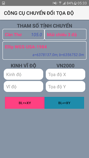
- Using 02 coordinate systems of Longitude, Latitude and coordinate system VN2000
- Support map zoom function, rotate Map along North-South axis
- Find and mark current location by name
- Electronic compass (supports only devices with magnetic sensors)
- Support to customize the transfer calculation parameters
- Save and Display points, areas, areas by Objects, Projects
- Change colors, hide objects, points in the Project
- Save the free drawn area
- View, Edit, Delete, Find Landmarks
- Function of navigation to objects, save points
- Support to re-draw the survey route from time to time
- Support function of displaying map styles from mapbox.com
- Draw Points, Polygonal Domains; Measure Distance, Calculate Area
- Export point data to .kml .gpx files
- Support importing point data from .gpx file
- Send and exchange data of saved points
- Supports converting tools between coordinate systems
Description
Information
Related Tags
You May Also Like
VIEW MORE


High Quality APPS
-
![Liftago: Travel safely]()
Liftago: Travel safely
9.7
500K
Maps&Navigation apk -
![BluSmart: Safe Electric Cabs]()
BluSmart: Safe Electric Cabs
9.7
1M
Maps&Navigation apk -
![GPS Voice Navigation: Live Map]()
GPS Voice Navigation: Live Map
9.5
5M
Maps&Navigation apk -
![Map air alert (UA)]()
Map air alert (UA)
9.5
100K
Maps&Navigation apk -
![SmartZooMap - National Zoo]()
SmartZooMap - National Zoo
9.3
1K
Maps&Navigation apk -
![Mgrs & Utm Map]()
Mgrs & Utm Map
9.3
1M
Maps&Navigation apk


